
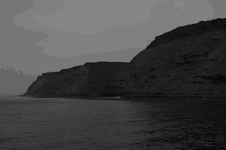
Cabo Colnett at sunset
We departed Wednesday night around 11pm from Marina Coral in Ensenada, heading south to Cabo Colnett. We were helping provide a marine biologist at the local university with bottom grab samples to help characterize the benthic invertebrate species within the several mile wide relatively shallow bay. Some of the samples we took were also set aside to be processed for POPs (persistent organic pollutants) and heavy metals. The combination gives researchers data with which to compare future samples using polychaete worms, and the sediments themselves as current baselines for the health of the bay and how human development; locally or in the heavy population centers not too far north, might be impacting the area. Until recently nobody had bothered with the expense of detailed marine monitoring in this area. With rather limited funding environmental monitoring programs in Baja need to pick and choose carefully, and; looking at the place in its current form, its clear why this wouldn’t be high on the list.
Backed against a crumbling cliff to the North and a small fishing village and surf spot to the South, Cabo Colnett supports an abundance of life and natural resources. However, development here looks much like it must have 100 years ago, a small collection of boats and shacks in various states of disrepair sit at the base of the cliff, no boat ramp to speak of, but a gentile gravel beach and a natural channel between the kelp forests to each side make for a natural substitute. There is ranch and farmland in the low valley further along the coastline, with a couple of houses here and there. There are no paved roads to anywhere within sight of the coast here and the fleet of open fishing boats that fish and dive the kelp paddies numbered less than a dozen on the day of our sampling trip. The small settlement to the south, Punta San Telmo had a launch ramp a church and a modest collection of old homes, which I presume are occupied almost entirely by the men we saw fishing and their families. There is also a surf camp for the “Cuatro Casas” surf break.
-Jeff Ernst
The peninsula known as Baja (Lower) California is undergoing uncontrolled, explosive development of its pristine coastline, largely as a result of its neighbor, Alta (Upper) California’s need to create infrastructure for its goods. Alta California refuses to allow these industrial developments on its own soil, because of the environmental and human health costs. Sempra Energy has built the first Liquid Natural Gas port facility at a beautiful headland known as Salsipuedes, in contravention of the Local Coastal Plan, which called for the area to be preserved as open space and natural habitat. It did this through heavy-handed political bribery. The gas will come by pipeline to the US and very little will be used in Mexico. The bay of Salsipuedes is the home of an aquaculture facility. In order to cool the LNG for shipment, 50 thousand cubic meters of seawater per hour will have chlorine added to it at the rate of 50 kg/hr. This water will then be pumped out into Salsipuedes bay after its temperature has been raised 7 degrees C. It is doubtful that the aquaculture operation, let alone the kelp forest and its creatures, can survive this relentless insult, day in day, out, year after year.
A second development, the mega-port of Cape Colnett, is currently being planned to take cargo which would have gone to LA/Long Beach, had the citizens of LA County not rebelled at the health and quality of life costs of expanding their ports to accommodate the goods of globalization (95% of all manufactured goods are transported by ships). This port will have the longest breakwater ever built, 8 kilometers, and enclose a huge bay, which currently has a great surfbreak (cuatro casas), an enormous kelp forest and a sustainable fishery. The point itself at Cape Colnett is reminiscent of Dana Point before development.
We just finished sampling 20 stations for bottom dwelling (benthic) organisms to get baseline data on what may be changed forever if the development goes through like Sempra’s did. There are three main reasons the project doesn’t make economic sense. First, the goods will go by a new rail line to the United States near the border of California and Arizona. Their final destination will be the Central and Eastern US, however. Second, the Arctic ice cap is melting and the Northwest Passage will be a reality for ships from Asia to reach the East Coast. Thirdly, the port will take jobs away from port workers in LA/Long Beach, since labor costs will be less in Mexico, and environmental protections will be less as well, lowering costs for shippers.
-Cpt Charles Moore
I’m including three other photographs although they are a bit lower quality than the last several posts because I have to use the satellite connection. We just dropped anchor off San Quintin and are planning to spend the night here heading out early tomorrow to keep making time south.
1: a sandstone cliff butted up right against the shore and a thick line of kelp
2: the only visitors to the beach that day

3: fishing the old fashioned way


3 comments:
Obviously the pictures failed to upload but; thanks for the comprehensive over view of your current mission. We first thought you were on a surfing safari (just kidding). It is sad to hear what is going on down there and it is perplexing that the news media never seem to be aware of what is going on unless it involves Britney or Paris. There never seems to be an end to government and industral greed. Environmental organizations sometimes create bigger nightmares when ignoring the economic impacts of their causes. There must be a better way to protect environments without causing economic disasters and new environmental problems. Communication and compromise never seems to enter into these problems. Is there any organization trying to hold anyone accountable for these decisions?
Jeff,
Your Aunt Sherry's surgery went well.
Dad
I hate to be a pest with multi-comments per day but; can you do me a favor? Google Earth is placing Cape (Cabo) Colnett on the east coast of Mainland Mexico, just north of the Yucatan Peninsula. I guess they can't everything right. Can you post the Lat/Long of your sample area?
By the way; the pictures that were missing from the last posting have appeared.
Post a Comment