July 31st 9am Coordinates: 21 15.57N, 158 04.07W
Land Ho!
We made it-51 days and 6,890 miles logged! We’re about an hour into landfall and were welcomed by the warm, still sunshine of the islands. The morning has been a bit hectic-we pulled into Ko’olina Harbor on the southwest side of Oahu with an hour and a half to spare before Christiana’s flight to the mainland. We are in the process of fueling up now and then we’ll motor our way 15 miles or so eastward to Kewalo Basin, where the Alguita will be slipped for the next several weeks as she is prepared for the 2nd leg of the voyage-the 10 year resample of our 1999 sample locations on a course from Oahu back to Long Beach.
The next few days will be spent decompressing and taking care of business. Drew will be heading back to the North Shore with his wife, Jaime, while the rest of us stick to the Honolulu area. We will be attending the Hawai’i Conservation Conference open house at ING Café on Saturday August 1st, hosting a potluck with the help of Surfrider aboard the Alguita on Sunday the 2nd (hopefully the boat will be sufficiently aired out from the 7 weeks of sea-funk-mold, mildew, and the wonderful aromas associated with 6 people in close quarters) and topping it off with a “open boat” on Monday the 3rd from 10am-12pm giving the public and press a chance to share in our research.
Update on the missile hot zone: Pheonix 1 wasn’t lying. Out on the back deck, eating cheesecake and watching our last sunset of the trip together, Christiana looked through a gap in the cloudy sky and said as a bit of an afterthought, “Wow, that looks a lot like a missile trail….” And sure enough it was. Off the port stern, there was a distinct missile trail heading to into the west. We were happy to be far enough from the launch to see the action and not feel it.
Thanks to everyone who has been following along on our journey! It’s been a unique and powerful experience for us all. Stayed tuned for a couple blog posts during the next week or so: there will be more pictures (they’ll be a lot cheaper to post and in much higher resolution now that we’re back on land) and personal accounts from the Captain and each of the crew members on our 7-week adventure.
Aloha from the Oahu,
Nicole
Friday, July 31, 2009
Thursday, July 30, 2009
Day 50
Noon Position 26 28.30N 159 41.22W
7/29
We are 245 miles out from Oahu and speeding along at 9.1 knots over the ground with 21 knots of wind. We are definitely in the trades now. This afternoon we passed back into the Exclusive Economic Zone (EEZ) of the U.S. and spotted Frigate Birds, both of which are a reminder that we are getting close to land again.
The day was a pretty standard transit upwind-other than being informed that were in an area which will become a missile hot zone by 5:30 pm tomorrow, the 30th. Jeff was on watch and was getting a crackling and inaudible transmission on the VHF radio. Apparently that inaudible crackle was the military trying to get in touch with us, so they decided to step it up a notch and swoop down over the bow of the Alguita in their plane. This got our attention. With the plane in closer range the transmission came in clear. The plane, which hailed us under the call sign Pheonix 1, informed us that in 24 hours the military was going to be testing missiles-right over the waters we were in. Pheonix 1 stated that as long as we maintained course (we were on a bearing of 140 or so) we’d be out of the way in time. A couple hours later Phoenix 1 made contact again, suggesting that we keep our course as easterly as possible in order to be clear out of the way by tomorrow evening. Needless to say, we are keeping out of the way.
The other excitement of the day was a product of beating into the weather. All the hatches have to stay closed since the foredeck is getting doused by waves--so the cabin is a little stuffy. Christiana gave into the stuffy heat earlier in the day (as we all have at some point) and opened up one of the hatches in the starboard cabin during a lull in splash, only to get her bunk drenched by an unexpected wave. Lesson learned. The hatch remained closed until, again someone couldn’t stand the mugginess of the cabin and re-opened up the hatch. This time the inevitable flood of water drenched Drew’s bunk-sleeping bag and all.
Our ETA is now sometime during mid-morning on the 31st, although this is still subject to the whims of the weather. We have put aside some time on Monday the 3rd, from 10am-12pm, to invite the public and the media to stop by our slip in Honolulu’s Kewalo Basin to check out what we have collected during our 7 weeks at sea. Hope to see some of our Oahu friends there.
Tuesday, July 28, 2009
Day 48
Noon Coordinates: 31°37'12.00"N 158°35'60.00"W
 July 27
We are motor sailing along at 6 knots on a course is 176, heading almost straight south towards Oahu with only 568 lovely miles to go. We've logged 6200 miles on the trip so far. Without our days broken up by trawling or stopping to dive a large piece of debris they’re all kind of starting to run together.
We hit winds of a steady 25 to 30 knots over the weekend….with gusts up to 40 and 50 knots! AS Jeff’s father pointed out to us, during this period we made the most headway in 24 hrs than we have in any of the past several voyages he has tracked!
It was a bit of a rough ride, beating into weather most of the time. At that point we were flying along at 8-12 knots with the weather hitting us at our beam. These conditions made for a noisy couple days. “Water bombs” were going off left and right. “Water bomb” is the term Drew has been using to describe the jarring “BOOM” that happens when the Alguita slaps down onto a swell. Walking around the vessel was quite a task during this weather. You don’t so much get the option of choosing where you are going as being forced to land somewhere by the yawing and slapping of the boat. The galley transforms from a place to prepare the food, to a passageway full of counters and random objects to brace yourself on your rocky journey to, well…the other side of the boat. Heavy weather also meant that the bilge alarm was going off again. There’s a hole somewhere that let’s water invade the port hull when the weather picks up (we thought we fixed it in Hawai’Ii, but apparently not). So what this means is that someone gets to pump out 5 gallons of mucky bilge water every 12 hours or so-which I must say is a small price to pay to keep the boat afloat.
The night shift on the 25th (Saturday) was particularly hairy-this was the night we saw gusts of 50 knots. The auto-pilot went out on Joel’s shift around 10pm and then morning team had to hand steer the vessel because the auto-pilot wouldn’t correct the course adequately.
The way Captain puts it, the Alguita is kind of like an albatross. When there is enough wind an albatross barely has to flap its wings-saving its energy and gliding along on the gusts. Only when the weather is calm will you see an albatross flap. Likewise, when there is enough wind the Alguita glides along, powered by sails and no energy is being spent. But when the wind dies, the boat has to flap its wings and so we turn on the engines.
Plans for our arrival in Oahu are in the works. It’s a little difficult to get things set up when our ETA is, well, a little fuzzy to say the least. We are hoping to arrive by the 30th. So far our plan is to get into the harbor at Kewalo Basin, take a day to clean-up the vessel a bit, and then invite the public and press to take a look at the debris we’ve found. There are also opportunities for us to present our research in a more formal setting. With the help of some of our Oahu based friends from Surfrider and Roz Savage’s support team we should be able to get something good going on the island.
If you live on the island and want to come by and say hi or have any ideas for a reception please contact Holly Gray at vesselsupport@algalita.org and she can put you in touch with us!
To all of our family, friends, and supporters thanks for continuing to follow the blog! It’s been refreshing to get the supportive and insightful comments from home.
On the home stretch,
Nicole

Friday, July 24, 2009
Day 45- Living on Liquid
 Noon Coordinates: 35°11'24.00"N 164°39'0.00"W
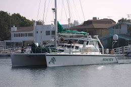
As we return to Honolulu and near the completion of our historic 6,000 mile voyage through the plastic soup to the International Dateline, I should tell you something about the extraordinary vessel that made all this scientific sampling of ocean plastic pollution possible. My “Little Kelp Plant” Alguita was not built on an assembly line. She was the product of a lifetime of sailing experience, years of research into vessel design, and collaboration among experts from the other side of the world. Her virtue is that she is the smallest, most economical vessel that can carry a crew of 6 in relative comfort while monitoring vast areas of the central North Pacific Ocean. You see, living on a liquid is different from living on solid ground. First off, you have to live in a container. Innumerable containers for this purpose have been designed over the years, but for sailing ability, interior space and providing a stable platform for research, I believe the catamaran tops the list.
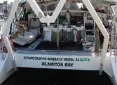
Oceanographic Research Vessel Alguita, Is 25 feet wide and 50 feet long, her two aluminum hulls set wide apart to provide stability. The underwing that attaches the two hulls together also serves as the floor or her ample bridge and galley. In a car, the noise of the tires rolling over the road can be made nearly inaudible to the occupants, but there is no way in a small boat, despite insulation throughout, to silence the whoosing of ocean waves being thrown out by the hulls. Additionally, the low slung underwing is only about 18” above the water surface, so that the whooshing is punctuated by waves confined between the hulls hitting it with a bang that feels like a car crashing over a tree stump. In moderate to heavy seas, we get frequent reminders that the particular liquid we are living on is not compressible. But what a sailor she is, with her main and genoa on a beam reach, she can easily do half the wind speed, and with her spinnaker set downwind, she sails along smartly.
 We have gotten the winds we wanted for our sail back to Honolulu, with a gigantic cyclonic low smashing the high that creates the gyre, and are currently whooshing along on a beam reach at 9-11 knots in a blustery 25-35 knot gale. Free fuel (wind), free energy (a kilowatt of solar panels), and free water made from seawater by a solar powered reverse osmosis system. With conditions like this, our range, like that of the albatross, is truly unlimited. Our most recent voyage was a lot like that of the foraging mother albatross, Amelia, in Carl Safina’s lovely book, Eye of the Albatross - leaving the Northwest Hawaiian Islands we passed through the Musicians Seamounts, reached the International Dateline, headed due north to the subarctic frontal zone, grabbed the westerlies there and headed back down to the islands. Alguita has provided hot water for showers, cold water to drink, fresh food to eat (we still have squash, eggs, onions, cabbage, garlic, yams, leeks, and a small watermelon and a pineapple), frozen food to thaw, a propane stove to cook on and an oven to bake in. We have done day and night dives and refilled scuba tanks with our electric air compressor. We have accessed our extensive spare parts locker to replace a failed water pump, used our many tools for numerous repairs, including a tap and die set to reset a stripped bolt on the port engine, and repaired many lines and sails with our marlinspike seamanship skills. We even patched a leak in the underwing, which gets impacted by debris like heavy fishing floats smashing into it as they pass between the hulls. So our container is an amazingly versatile and functional one, not only for living safely and economically on liquid, but for studying its unknown, but important qualities. Thanks to the Algalita Marine Research Foundation, we have been able to keep Alguita involved in research important to marine conservation for the past 15 years.
Whooosh - woops, there’s another treestump, bang thump, but hey, for 10 free knots of boat speed its worth it!
Captain Charles Moore
1000 miles north of Honolulu
Thursday, July 23, 2009
Day 43- Balloon
 Noon position: 39°18'31.80"N 170°23'19.20"W
5400 miles into the trip, 8knots over the ground, 20 knots of wind
Captain has been on a cooking spree the past few days: a curried lentil and squash soup one night, green chili beef and bean stew the next, and hamburgers tonight. These tasty meals followed by relentless snacking (Jeff is the king of killer snack plate composition) have made for a sluggish crew the past few days. Well, sluggish in between the sail changes and boat chores. No trawling can be done in this sea state (we learned our lesson on the first leg with the broken Manta, plus our priority is making good time to Honolulu) and the weather hasn’t exactly created the most welcoming deck conditions (it’s rainy, and windy, and cold). Drew has still being doing his morning debris watch which involves tracking the minutes to his first debris sighting of the morning. He clocked a record 10 minutes the other day. That was the longest period of time he’s had to wait to spot debris after walking out on deck.
Needless to say, we have a lot of time to reflect on what we are finding out here. The other day we pulled up a balloon out of the water. It was the knotted end of a bold turquoise balloon attached to some sort of plastic clip. There was no fouling and it appears to be fairly recently deposited. It would have taken years for the balloon to make its way out here via ocean currents. Perhaps it caught some wind off of Japan while it was still inflated or maybe it was released off of a cruise ship passing through the Pacific.
This is the second balloon fragment of the trip. Towards the beginning of the voyage we pulled in a balloon ribbon on one of our fishing lines. As Captain Moore has pointed out several times-balloons are key examples of a frivolous use of plastic. They are mass produced and are now a celebratory staple of sorts at birthday parties, graduation ceremonies, school dances-the list goes on. I remember arches of hundreds of balloons created for high school pep rallys and football games. After the events, sometimes the balloons would get popped and other times they’d been ceremoniously released into the sky.
I was recently a part of a team from CSU, Long Beach’s Environmental Science and Policy Department that was focused on trash accumulation and categorization at the Colorado Lagoon. The Colorado Lagoon is remnant of the historical Los Cerritos Wetlands Complex which is one of the few (although highly degraded) remaining wetlands in Southern California. Balloons, or fragments thereof, surfaced several times in our transects. They are polluting the most remote parts of the world (the middle of the Pacific Ocean) as well as our terrestrial ecosystems.
Anyway, the point is we have stopped questioning some of the cultural practices that contribute to our excessive waste stream. When looking at the practice of celebratory balloons from a rational point of view, it’s a waste of resources and a ridiculous use for a material that is known for its long life span. Balloons are used once, typically on the scale of hours at a time. Why use an everlasting material for this sort of practice? Furthermore why release this material ceremoniously into the environment. Balloons aren’t even close to being the dominant source of waste in the NPSG, but they serve as an allegory for the effect our normalized actions can have on the bigger picture.
Wednesday, July 22, 2009
Day 42
Noon position: 40°50'29.98"N 173°19'55.80"W
We are 5,200 miles into our journey and back in the western hemisphere, starting to make our way south with a heading of 115. Our speed over ground (SOG) is 7.6 knots and we’re getting winds out of the west at 20-25 knots. These are the winds we want to see-the Captain and crew are anxious to make it to Honolulu. We all have prior commitments that have been put in jeopardy by the weather conditions.
The winds started really picking up yesterday evening, jumping from 6-8 knots in the AM to 20-25 in the PM as we headed north. We took advantage of the situation by sailing downwind with the lovely, yet hard to please, spinnaker. For a while the winds were hovering around 30 knots, throwing large rolling swells at us which compromised the accuracy of the autopilot system. We were flirting with a disastrous collapse of the spinnaker and it became necessary to steer by hand. Drew was first in line for the job and Captain came in to relieve him after an hour. Christiana and I were watching his technique (how much to turn the rudder to compensate for the swells, when to overcorrect, when to make small adjustments, etc.) when we looked up to the sudden, violent collapse of the sail.
The crew donned life vests and rushed to the foredeck to fish the sail out of the water. The damage to the sail was pretty severe. On top of a second broken spinnaker halyard there is now a huge tear running up from the foot of the sail. We lost the most efficient sail for the current weather conditions-which lowered the morale a bit. Of course, we still have other sail options and have been making do with various combinations of the Genoa jib, Stays’l, and mainsail. Part of our issue is that the nature of the area in which we have been sampling is a high pressure zone. High pressure zones are characterized by light winds. We needed to spend the fuel to motor through these calms to in order to even run the Manta trawls. The past several days have been working towards an escape from these conditions, using sail power and not trying not to use the ever dwindling fuel supply. Our plan of escape: sailing north. This may seem a bit illogical since our destination is way south of us, but there just so happens to be a rhyme to our reason. Here’s Joel on the subject:
“Since we are a sailing vessel and we must sail to get home, we need to find where the favorable winds are. The wind and currents in the North Pacific Ocean are dominated by the large gyre at its center. The wind in the California Current flows from north to south and is the eastern edge of the gyre, the Trade Winds blowing toward the west and southwest make the southern boundary, the Kurshio current flows south to north off the east coast of Asia makes the western edge of the gyre while the westerlies blow back toward the West Coast of North America and make the northern boundary of the gyre. (note: keep in mind that winds are named for the direction they originate from. Thus westerlies come from the west, easterlies from the east etc.). All together they make a giant clockwise circular current and wind system with high atmospheric pressure and calmer variable winds at the center known as the North Pacific Subtropical Gyre. It is one of five major gyres in the world’s oceans. There are three in the northern hemisphere (The North Pacific, North Atlantic, and the Indian Ocean) which spin clockwise. In the southern hemisphere the South Atlantic, South Pacific and Indian oceans spin counter clockwise.
The most direct course home would have been to motor into the trade winds in the southern part of the gyre, but since we need to sail to get home we must go north and find the westerlies which blow to the east. Once we go far enough east we will make a right hand turn and will have to pass again through the center of the high pressure system which is blocking our path to Hawai’i. The light and variable winds from the gyre will eventually hook us up with the trade winds and we can use them to hastily return us to Oahu.”
The Corilolis Effect is the driving force behind the current and wind systems Joel described above. In the most basic sense, the Coriolis Effect is a result of the west to east rotation of the earth. This means that air flow is affected by this motion. For example, an object on a trajectory directly from the North Pole directly south would be deflected to east. In the southern hemisphere, an object traveling from the South Pole northward would be deflected to the west. Air pushes water to create surface currents, thus the deflection I just mentioned from high pressure systems, combined with boundaries created by earth’s landmasses encourage the dominant currents, like those described by Joel to maintain their clockwise (northern hemisphere) and counterclockwise (southern hemisphere) rotations.
Furthermore there are several convection cells of air resulting from the combination of the rotation of the earth and the differential heating of the earth. So the sun hits different parts of the earth at different angles. The more direct the angle of sun exposure, the more that surface will be heated. This is why it is so hot along the equator, where the sun hits directly for much of the year, and so cold towards the poles where there is little direct sun exposure. This differential heating results in the rising and sinking of air. Cool air sinks, warm air rises. So as air is sinking and rising (on the macroscale) as well as being subject to the Corilolis force dominate wind patterns, such as the Tradewinds (named for the reliability of the winds for trade) are established.
On another note, reports from the wildlife front: Christiana dissected two fish today-a large flying fish (we think it’s Hirundichthys albimaculatus based on the key we have on board) and the first tuna of the trip (it was an Albacore). No plastic to report in either of them.
Two nights ago we were visited by a half dozen friendly Leach’s Petrels. Well not so much friendly as they were attracted to our running lights. It’s a dangerous situation for the birds to be hovering so close to the moving vessel, there are far too many lines and hard surfaces for them to maneuver around. But it’s also not an option for us to shut off our running lights-that would put us in a lot of danger. The story ending happily though-none of the birds were hurt and we were entertained by their spastic flapping and their almost monkey-like chirps.
We are still finding debris, although it is significantly sparser. The areas we are transiting through at the moment are thought to be contributing waters and not accumulation zones of debris. Visual observations from the crew confirm this theory-although the waters have been quite choppy which makes anything but the large and prominent debris very difficult to spot. Bottom line, we still encounter debris after a few minute stint on deck and we have yet to pull in a trawl (we’ve done 42 so far) without plastic fragments.
From the Pacific,
Nicole
Tuesday, July 21, 2009
Day 39- A dolphin encounter unlike any other!
Noon position: 39° 8'11.98"N 179°59'47.76"E

July 18, 2009
As a SCUBA instructor for Surf and Sea in Haleiwa Oahu, I do get periodic times to swim with Hawaii’s favorite spinner dolphin, I have even had the opportunity to see bottlenose dolphin. Be it all of these encounters were wonderful and exciting in their own right, nothing prepared me for what I experienced last night.
After my usual 2 am wakeup call from Jeff to begin my night watch on another night of motoring through a windless calm at about 4 knots, I noticed an unusual glow coming from the water off of the stern of the boat. I quickly realized that the green column of water trailing the boat for about 100 ft was the bioluminescence resulting from the port engine propeller. Bioluminescence is the glowing green light emitted by a reaction within certain planktonic organisms, when their surrounding water is disturbed. Unless you are on a boat at night in plankton rich water, the next best way to see an example of bioluminescence is to swim, snorkel or dive at night, then turn off your lights and move your hand back and forth through the water. You should see some tiny green swirling lights around your hand. The more plankton in the water, the more lights emitted.
Well the waters out here are so rich with plankton, that when Jeff told me I should see the bioluminescence from the bow, I was astounded at what I saw. The catamaran left 2 bright glowing green waves and green swirling lines that followed the bow wake pattern. All the while, bright green bursts could be seen as larger sources of bioluminescence were triggered by the pressure wave in the water. The sound waves of the engine would trigger the reaction in the larger pelagic planktonic organisms deeper and further ahead of the boat, so they would “light up” as we approached. The waveless, windless night combined with a vantage point less than 3 feet from the water’s surface made this a once in a lifetime occasion for me.
I decided to take my camera and a cushion to lie on and see if I could capture this incredible visual spectacle on videotape. Well as any digital videographer can tell you…yeah right! Although the Sony SR11 donated by Reef Photo, is great for the underwater video application, there is no consumer camera with that capability to record what I was seeing.
After 10 minutes of just gazing at this phenomenon, I was suddenly startled as 2 large green streaks shot from beneath the boat, between the hulls and splashed to the surface right in front of me, then split to either side of the boat. Three more streaks shot in from port side and I could see clearly through the water that unmistakable shape...Dolphin!
The only way I could describe it was the dance of the sugar plum fairies out of the movie Fantasia, only with dolphin making the trails. I could watch them go deep and the green glow would get dim and then get brighter and brighter as they got close to the surface again...then splash they would break the surface. The shape was created by the glowing green bioluminescence generated as the graceful swimming machine moved through the water.
It was like watching an animated movie with special effects…it was surreal!!!! I could clearly see the details of each animal as it swam under my nose just out of arms reach. Tails, fins, body, were all clearly visible with the green outline through the clear calm water. Within seconds I had 10 to 12 dolphin doing what dolphins do….playing in the wake of a boat. The dolphin kept shooting in from the sides, darting up from the deep, two or three at a time, swirling in front of my face, each with its own green silhouette and ocean meteor trail extending at times, up to 20ft behind each powerful tail.
For only the second time in my life, my breath was actually taken away. I sat for what must have been 5 minutes in complete amazement by the visual ballet being performed just for me. With tears building up, I thought this is not fair that my wife Jamie couldn’t be here to experience this with me, this is just one of those times you want to share with loved ones. I then thought, maybe I should wake the crew.
Well Christiana was first to show up and the dolphin continued the show. At one point we saw a big green ball rise from deep beneath the boat only to explode into 5 individual silhouette trails dancing apart, then coming back together as the graceful sea mammals continued their dance while trails from flying fish scattered about. Nicole and Charlie finally got up in time to see the show before the dolphin went on their way, but Joel and Jeff didn’t leave their bunks…oh well, their loss. We think they were the same pod of common dolphin that came by after the sun came up.

One of the things that crossed my mind while watching this light show that was taking place, was the question of what it must look like from underwater and the realization that, dolphin have good eyes so they get to see this all the time from under water. Just another reason why I believe when it comes to rank on the life ladder, we are several rungs below the dolphin, they are just designed too perfect…they don’t need technology to create their own light show.
This will rank as one of the greatest experiences of my lifetime! It’s just sad to think they have to swim through all that plastic that I see during the day.
Writing and photography by crew member Drew Wheeler (Thanks Drew!!!! )You can learn more about his underwater videography at http://www.scubadrewvideo.com/ and follow his account of the voyage on his blog at http://trashvoyage.com/
Saturday, July 18, 2009
Day 38
Noon position: 37°30'18.00"N 179°12'18.00"E  Photo: ScubaDrew videoworks
 Photo: ScubaDrew videoworks
Today was gloomy-starting and ending with rain, although it was kind of nice to get a break from the strong sunshine. Since we are motoring at such a slow speed anyway, anywhere from 2 to a whopping 4 knots, we decided we weren’t loosing much headway by throwing out a manta trawl this afternoon-and yes, there was plastic. Based on reports from Drew about the density of debris particles flowing by the boat we expected to see a lot more plastic in the trawl. It seems that by the time we set up and deployed the Manta trawl we had already passed through the denser band of debris.
We pulled in the third industrial grade white plastic bag today, although this one was a smaller piece and did not have the blue Japanese characters. Based on the fouling level and the identical nature of the plastic material we are pretty sure it’s a member of the same bunch. That makes three within four days.
Strange event of the day: an attack by a wooden spool stuffed with beer packaging. Drew spotted something “really big” dead ahead of us from his debris gazing spot on the foredeck. I popped up through the hatch with some binoculars and discovered that is was a large wooden spool for wire (about 3.5 ft tall and 3 feet in diameter). We approached it with the boat in idle forward and tried to hook it from the front. The cagey little spool evaded the debris wranglers and ended up bouncing off the port hull. Oops. No harm done thankfully.
Captain dove of the aft deck and into the water to attach a line to the spool before it got away. We hoisted it up on deck with the gantry to find two Baltica brand 6-pack beer packages (it’s a Chilean beer) stuffed inside along with a couple stowaway crabs. Upon closer inspection we could tell this was relatively recently deposited debris (based on the lack of fouling and perfectly intact structure) and Captain estimated it was likely jettisoned within a 100mile radius of our position (37 33.84N, 179 13.25E).
The spool was wooden with metal odds and ends, so it will all eventually degrade into basic elements and it is relatively inert. An object of that size is however a significant threat to ocean going vessels-as we experienced firsthand today. According to MARPOL Annex V (the International Agreement on Maritime Pollution) placard displayed on aboard the vessel (a legal requirement on boats over 25 feet long), plastic is the only material regulated over 25 nautical miles off of land. While plastic is banned from being dumped from vessels throughout the entire ocean as it should be, it seems to be a bit of an oversight to allow large and hazardous debris to be dumped at any location. Even some place as remote as the middle of the gyre is still periodically traversed and things deposited out here will eventually find their way south toward the higher traffic waters near the Hawaiian Islands. MARPOL is up for reauthorization soon, and given that the information on our placard is correct, this might be an issue worth looking into.
Wildlife report: Captain and Drew spotted two Fin Whales, a cow and calf, this morning and there were some more spouts spotted later in the day. Backtracking to critters from the night dive: I completely neglected to mention that we spotted a Hyperiid amphipod (Phornima sedentaria). Why is this exciting and what is it? These critters are crazy zooplankton commandos that commandeer the body of salps to make a salp suit. Just before we dove Christiana was telling us the alien from the movie “Alien” (the creepy little thing that bursts from the stomach cavities of the crew) was designed after the Hyperiid amphipod. Look up a picture-you’ll see why.
From the gyre,
Nicole
Friday, July 17, 2009
Day 36 & 37
Noon Position (Day 37): 36° 3'19.80"N 179°36'5.40"E (Nudibranch- awesome photo by Jeff Ernst!!!)
 (Nudibranch- awesome photo by Jeff Ernst!!!)
Yesteday, Day 36, was the day of black water-we did a black water tank cleaning and had the opportunity for the first “black water dive” of the trip (aka: night dive, thankfully not some sort of foul operation involving the boat’s waste water). The starboard cabin crew (Drew , Christiana, and myself) have the wonderful opportunity of living right above the black water tank. Most of the time the cabin/tank relationship isn’t an issue. When it’s starts to get full however, our cabin takes on a VERY pungent seweresque fragrance. Over the course of the trip it’s started to be more persistent, so we decided to battle the stench front of our cabin with a mouthwateringly scented Cherry tank cleaner (yes, it’s inert-no harm to the ocean). Lack of tank stank equals a happy crew.
We set out 4 trawls throughout yesterday, still finding plastic in all of them, although in varying densities. We are starting to bring up some different and interesting critters in our trawls. A couple days ago one trawl was filled with Nudibranchs -adorable little guys.
Still logging disturbing amounts of debris throughout the day, although under sail it becomes much harder for us to maneuver to retrieve them. We found a replicate debris item yesterday, a white industrial plastic bag (similar to a trash compactor bag) with blue Japanese characters. The first one we logged was on the 14th and was lightly fouled with fish eggs and bryozoans. The bag from yesterday was also fouled with a few barnacles and some bryozoans. This got us to thinking about the source-a container spill or a waste lost from the same vessel perhaps.
The day progressed into the semblance of a delicious Thanksgiving in July feast-mashed yams with glazed walnuts, grilled chicken, and cranberry sauce with some other random dishes thrown in. We had been waiting for perfect night dive conditions, which decided to come around as we were heavy bellied after our meal. But we couldn’t pass up the opportunity.
Joel, Drew, Christiana and myself dove on tanks while Jeff free dove with the Sea Dawg-an awesome underwater scooter. Captain stayed on board, monitoring the divers. Being 40 or so feet underwater, surrounded by bioluminescent creatures, 3,100 miles out from Long Beach, with a couple miles between us and the bottom was surreal. At one point Joel, Christiana, and I huddled together, shut off our lights, and let ourselves get a full dose of the bioluminescence. It was like floating in a bed of stars-very serene and surreal. By waving our hands through the water or kicking our fins, we could light up a swath of critters-enough to clearly see each other in the pitch black water (with some help of Drew’s camera lights). We surfaced to a vibrant night sky with a perfect view of the Milky Way. We are a lucky bunch to have the opportunity to be out here. Although the subject of research is a little grim, there are many positive angles to our situation like diving in a place where no other humans have likely ever set foot (or boat?) We are able to stargaze, free of urban light pollution. Jupiter drifts low across the night sky and we’ve come to notice that it has its own “moonbeam” on the ocean’s surface--pretty cool!.
We woke a tired yet content crew from the night excursions. The trawl was put out some today and Drew and Joel worked on educational footage for their grant with Kahuku School. Given that we have been working diligently to collect data, it time to focus on a timely return. The priority is being shifted toward making it home. We are crossing our fingers that we will pick up some stronger winds as we head north a bit and then end up in the easterlies which will deliver us to Hawai’i.

From the Pacific, Nicole
Wednesday, July 15, 2009
Day 35- We’ve reached the Dateline!!
Noon Position: 34° 0'36.00"N 179°53'34.80"W
 We’ve reached the Dateline!! Finally, 35 days out of Long Beach and 4,441 nautical miles into this mission and we’ve reached our goal, the International Dateline. This latitude line is both 180˚ E and 180˚ W and is a brand new line of sampling to add to the databank! Our transition into the eastern hemisphere (and into tomorrow) was quite the picturesque “after school special” moment. The sun was shining and the ocean was glassy. A pod of Striped Dolphins was performing starboard of the vessel and an albatross or two was flying about. The crew was gathered on deck as Captain watched our position from the helm, counting down our approach to the Dateline over the hailer. We crossed, and yes, at that moment, the dolphins decided to up their performance to some aerial moves. Captain joined us on deck and we relished in the moment of achieving our goal for a bit-the conversion tending towards the usual, marine debris.
Before we reached the Dateline, we had a strange run in. Around 9am, I was directed from the debris spotters on deck (Captain and Drew) to turn hard starboard so we could fetch an obscure piece of debris in the distance. As Captain was dipping down the net to retrieve it he realized that it was far from marine debris-it was a sea turtle (it's been difficult for us to ID it as it passed by so quickly, but it's either a Hawksbill or a Green). The presence of this guy highlighted the reason marine debris is such a tremendous issue; the juvenile turtle was feeding in an area where we had been fishing out debris all morning, introducing the possibility of plastic ingestion. We have documented the tangle of debris and zooplankton that surrounds us (see photo below). It is easy to imagine how the plastic fragments could be inadvertently scooped up-and marine debris ingestion in sea turtles has been recorded. We got some footage of the turtle (it has a large white mass growing off its shell) and Drew jumped in to get a better underwater angle on our reptilian friend, but he caught onto us and took off into the blue abyss.

So now that we are at the Dateline we are doing what we came here to do-sample, sample, sample. Manta sample #29 was the pioneering trawl--the first of the Dateline series, and the first Algalita sample in the eastern hemisphere. Refreshingly, we pulled up only 3 plastic fragments in the trawl (at least from what we could see with the naked eye). Manta sample #30, deployed a ½ hour after #29, produced a ridiculous amount of plankton. The sample was backfilled out of the cod-end and up into the sock of the net. It took up a 3 gallon bucket (for reference, the average sample we pull out is about a 1/2 liter or so). It wasn’t feasible for us to save the whole thing (we are running low on formalin to preserve the organics in the samples) so we rededicated portions to the education sample stock. Manta sample #33, the last of the day, ran for a half hour and produced an astounding amount of plastic. A stark contrast to Manta #29 deployed 3 hours (roughly 9 nautical miles) prior. As I stated yesterday, the trash accumulation zone is patchy and tremendously dynamic.
Before the trawling and Dateline crossing, we spent some time discussing our protocol for debris documentation in order to maximize the value of the data gathered on future voyages. Our focus has been on researching the small scale debris pulled in from the trawls and we are still learning how to best approach the documentation of the larger debris we are encountering. The whole protocol discussion process inevitably ended up delving into the Alguita, which turned us on to Jeff’s old oceanography book he contributed, which then lead to the ultimate quiz session. We passed quite a bit of time picking random oceanography terms and testing each other on our marine realm vocab. Oh the ways you entertain yourself at sea; spending time learning new and obscure knots, playing chess (the Jeff-Joel chess score: Joel up, 26-20. These boys are chess machines.), exercising, cooking, snacking, reading, looking in fish (if you’re Christiana), repairing boat parts, expanding your language repertoire (Greek, Spanish, and Japanese have all been dabbled in), seeing how many bird shots you can get with your telephoto lens (if you’re Jeff)……the list goes on.
We are chugging along at 3 knots with the main and Genoa up, banking on some more wind to come our way as we head north. We will continue sampling along the Dateline for the next 300 miles, up to 40N and then head east after we pick up the westerlies to start our return to Hawai’i.
From the International Dateline,
Nicole
Tuesday, July 14, 2009
Day 34
Noon position: 34°15'39.60"N 177°44'31.20"W
 7/13/09
80 miles out from the Dateline and the seas are thick with debris and plankton. We did two 10 minute debris counts today, the morning one yielding 37 pieces and an afternoon one 87 pieces. I realized today that the Alguita has sampled as far as the 170th parallel on previous voyages, and we are now at 179W which means the past several days have involved sampling in previously un-sampled waters-exciting!
We typically set out Manta trawls for a period of 1 to 2 hours, but yesterday we could only set the trawls for 15 minutes because the plankton was so dense that it quickly clogged the cod end of the net. While these trawls were delivering high amounts of plankton, the amount of small plastic debris was keeping pace. Within yesterday’s series of 15 minute trawls (we did 4 in total) we noticed a gradient in plastic density. There was a marked difference in the plastic level observed in the first trawl, which was heavy in plastic, and the last of the series, which was pretty light in plastic content. This was covering a distance of roughly 2 nautical miles which just goes to show how dynamic the debris accumulation is throughout the gyre.
The education trawl was pulled up wounded from some sort of underwater battle. There was blood pooling in the end of the net and holes ripped in the mesh. Apparently something tasty was trapped inside of the net which something else wanted to eat to bad enough to tear through it. Several chains of baseball stitches later and the net was back in action.
This morning Charlie and Drew got in the water while the rest of the crew was fast asleep to dive a buoy they had captured. As the Captain de-barnacled the debris underwater he became the new refuge for the fleeing crab. Later in the morning we spotted a second buoy with a thriving ecosystem-juvenile Rainbow Runners, crabs, gooseneck barnacles, so we decided to dive it. The bad part about diving in dense plankton zones-the jellies. We were all getting stung left and right by these mesmerizing, yet painful critters.
Later in the afternoon we encountered the most bizarre debris of the day; a laundry basket filled with fish. It’s not every day a basket full of fish comes floating your way while you’re in the middle of nowhere. Tiny Rainbow Runners and a few Pilot Fish were stuck inside the basket (at least until the seas got rough enough to throw them out). When we pulled it out of the water we found coral growing on the bottom. A few of the fish were preserved for lab work up and the rest of them were analyzed on board for plastic content, thankfully with no plastic to report.
 It’s been glassy calm the entire day, shifting from a perfectly sunny morning to a gloomy, rainy afternoon, and ending with a stunningly starry night. As characteristic of the gyre, the winds are light and variable. We’ve been running through a flurry of sail changes trying o maximize the wind.
Thanks to Jeff’s mom Kathe for the awesome “Friendship Soup” recipe which we enjoyed the other night!
From the thick of it, Nicole
Sunday, July 12, 2009
Day 32
 Noon Coordinates: 34°14'27.60"N 174°18'25.20"W
Styrofoam is a copyrighted term for a Dow Chemical insulation material. The generic term for the spongy white cups and take out containers we are all familiar with is expanded polystyrene. Photos of waterborne trash accumulations from urban centers invariably show large quantities of expanded polystyrene containers. When polystyrene - think clear CD cases that crack - is expanded, gas is dispersed into the melted polymer creating innumerable channels and bubbles in the material. This makes it a good insulator for hot beverages and food, and gives it a texture that is easy to handle. It also makes it float, since plain polystyrene is heavier than water. Dr. Anthony Andrady, Algalita Marine Research Foundation’s lead polymer scientist, conducted experiments with different types of plastic in the ocean and on land to determine how they lose flexibility, become brittle, and break down into fragments. He found that all plastics except one, expanded polystyrene, broke down faster on land than in the ocean. For most plastics, heat absorption was the key to rapid embrittlement, and the cooler ocean environment acted as a heat sink, slowing the process. But with expanded polystyrene, the increased access of seawater into the pores of the plastic accelerated breakdown more than the increased heating on land. Dr. Andrady found that expanded polystyrene was the only common plastic to break down faster in the marine environment. When I sampled the Eastern Garbage Patch, halfway between San Francisco and Hawaii in 1999, I only found about 10% of the particles in our trawls were expanded polystyrene. These most probably originated in debris from Asia following the debris highway created by the Kurashio current’s easterly extension. Now that we are nearly two-thirds of the way to Japan, we would expect to see more expanded polystyrene and to see it in a less degraded state. This is indeed what we are finding, little bits, medium sized pieces and big blocks.
As we approach our goal, the International Dateline, (we are now at 175 West Longitude, only 5 meridians to go), we also are seeing more Asian PET drinking water and soda bottles. Since the caps are made of Polypropylene, not PET and degrade faster, when the caps crack, the bottles fill with water and sink, so we don’t find as many of them in the Eastern Garbage Patch. The Asian origin of the debris is corroborated by markings on much of what we are finding. A Taiwanese fishing float stating “Yung Plastic Industry, Republic of China,” a Japanese Coca Cola bottle, a thin piece of plastic film with Chinese Characters and a Japanese survey stake. All of this debris creates an amazing habitat for a great variety of free-floating larvae looking for a place to settle on and grow. According to David Barnes, of the British Antarctic Survey, plastic debris at the surface of the ocean has at least doubled the mass of the organisms living there. Not only are new species showing up on plastic transported to coastal environments where they have never been before, species that normally live in coastal habitats can be found associated with debris in the deep ocean. This is analogous to the introduction of European weeds and pests into the New World, species that displaced and decimated the natives. It has been speculated that this mixing of biota could result in a reduction of species diversity in the ocean by half.
From Captain Charles Moore, sailing toward the dateline aboard ORV Alguita.

Saturday, July 11, 2009
Day 31
Noon Position: 34°38'13.20"N 172°53'25.80"W

Today was our rest day (although we did set out education trawls and dive for debris still :) Here are a couple pics. One is the cod end of the trawl underwater, the other is a sunset with debris we have collected on deck.


Friday, July 10, 2009
Day 30
Noon position: 35° 3'54.00"N 171°37'40.80"W
It’s been super calm, and we’ve been taking advantage of these conditions to do some continuous trawling. We are bringing in our third trawl of the day-they have all been thick with plastic. Among some of today’s debris finds: a black plastic bag fragment, bottle caps, and an oil bottle which weaseled its way into the Manta trawl. Notable wildlife find of the day: a Hatchetfish (Captain found this little deep water fish while putting around in the dingy, at the surface-quite a ways from home). I did another fragment count today off the bow: 48 pieces of plastic floated past in 10 minutes. About half the frequency I recorded on July 4th, but still pretty astounding.
While the afternoon trawls were out, we had a string of exciting events. Jeff and Drew jumped in the water with some dive propulsion vehicles (aka underwater scooters) in order to get some more underwater footage of our trawling procedures. Once in the water, they spotted a pair of Mahi and Joel decided to dive in and take advantage of the opportunity to collect a research specimen. After a gypsy call emerging from Drew’s snorkel, Joel was pointed in the direction of the fish. He speared the bull. The big guy was especially feisty and tried to bite Joel’s groin several times. Luckily he was wearing a wetsuit and Mahi don’t have especially fierce teeth. This was Mahi number 13 and at 40lbs he was the biggest we have pulled in so far. After a struggle, we got the fish up on deck and Christiana was able to do her thing. Here is what the resident fish nerd had to say about the findings from her dissection:
“I did not find any plastic in the Mahi’s stomach, but I did find some really interesting creatures. There was a cornucopia of parts that I was able to put together--like a forensic puzzle. I felt like a scientist on CSI: Pacific Gyre. There were parasites, squid beaks and mantles, fish jaw bones and skulls, a crab carapace and claw remnants, and a completely intact lanternfish (Family: Myctophidae). This was an amazing discovery for me because it shows that Mahi feed directly on laternfish. From my research on the laternfish collected from the 2007-2008 gyre voyage, I found that these particular fish had ingested a ridiculous amount of plastic. What we found today is a full circle; humans have created this mess in the ocean and we are now stuck consuming it. I really hope that our efforts out here get people more motivated to prevent this problem from getting worse.”
While it is a significant opportunity to be able to catch this fish for research, there are mixed feelings about the catch and dissection process. Drew recounts his sentiments after getting the opportunity to film the Mahi underwater, “I was a visitor in his domain. He was a majestic and proud. It was sad he had to give his life up for science because he was such a beautiful fish.” Bottom line, the crew of this vessel respects and appreciates the creatures of the ocean-but it has become our burden to dissect and document them in order to wake up the general public to the repercussions of our actions.
 After we processed the fish, Captain, Christiana and I went on an expedition this afternoon. Since conditions were so calm, we decided it was high time to take the dingy out. It was bizarre to watch our home for the past several weeks disappear behind us, but at the same time it was nice to escape from the boat for a bit. We cruised along looking for debris, which is a little harder to spot from the low vantage point of the dingy. After a few minutes we ran into a float-which from a distance looked like a large Japanese glass float. It turned out to be a standard buoy. It was a 300mm float made by Yung Plastic Industries Co. in Taiwan. There was a huge population of barnacles layering the lines attached to the buoy and a decent sized community of juvenile Rainbow Runners taking refuge under the debris. We had some time to jump in the water and film the synthetic habitat while we were waiting for the Alguita to catch up with us. Getting the buoy back onto the vessel required a bit of muscle-there were about 100 pounds or so of barnacles attached.
The evening has been spent doing some standard boat housekeeping-hosing decks, cleaning the debris (barnacle shucking needs to happen to help keep the stink down, which ends up wafting into the starboard cabin), sorting out old produce, etc. We are 399 miles out from our desired sampling location and near the 4000 logged mile mark for the trip! Winds are still low and variable at around 5 knots. We have been making a plethora of sail changes the past several days, trying to exploit the few decent bursts of wind we are afforded. The spinnaker is up for now and she requires tons of attention in these light winds to keep her filling. She does a sort of belly dance which is graceful on a large scale.
Wednesday, July 8, 2009
Day 28
Noon coordinates: 34°22'55.20"N 169°12'14.40"W
July 7th, 2009
Once everyone was up and about this morning, Captain decided it was time to take down the main and put the spinnaker back up. The chute is our best shot at making a decent speed toward our sampling destination. We are running too low on fuel to continue compensating for the weak winds by motor sailing.
As we were prepping to drop the main halyard we discovered the line was jammed in the jammer-not good news. It turned out the repair job from yesterday was more of a problem than a solution; the repaired sheath was the jamming culprit. So, Joel foolishly (in his own words) volunteered to go to the top of the mast and replace the main halyard with the backup halyard. This required hoisting him up 50 feet or so in the boatswain’s chair. Immediately after getting up the mast he spotted a ghost net, which we were unfortunately too preoccupied to retrieve-safety first... Unfortunately for the already motion sensitive Joel, the sway of the vessel is amplified atop the mast. He got seasick and the unsuspecting Captain and I to got doused from above with Joel’s breakfast. One flying hammer later (good thing we had hard hats) and the switch was complete. Joel charged through his bout of seasickness and got the job done, earning the crewmember platinum star for the day.
 We were spotting debris left and right, so after the halyard business we put out the Manta and an education trawl. While the Manta trawl samples will be analyzed back at the lab, the education samples will be used for outreach purposes. In fact, Algalita Educators Marcus Eriksen and Anna Cummins just wrapped up a 3 month education tour of the west coast of the U.S. They cycled down the coast stopping along the way to pass out education samples to educators, legislators, and community.
Interesting trash find of the day: a Japanese honey bear bottle and ½ a trash can lid. Wildlife citing of the day: a close encounter with a Black Foot Albatross. And by close, I mean close. We stopped for a swim in the late afternoon. While netting and documenting debris with cameras and video equipment, we managed to spark the curiosity of part of our albatross fan club (they are still following the Alguita). She landed right next to us and proceeded to ham it up for the camera. She was tagged, however she didn’t sit still quite long enough for us to get the information off of her band.
Early evening sent Jeff up the mast to finish the halyard repair process. Thankfully, he made it up and down the mast without any event to speak of. Our day ended with the accomplishment of what we had set out to do much earlier in the morning-raise the spinnaker.
We are making headway, although not much, toward our goal sampling zone. From the amount of debris we are bringing on board, it seems as though we are in the thick of the plastic soup at the moment. Every survey over the water surface unveils the presence of some sort of debris-small fragment or otherwise. At this point we have logged over 110 larger pieces of debris, and have yet to bring in one Manta trawl that was free of plastic. The past several trawls have been especially disturbing, blanketed with a layer of floating plastic particles.
From the thick of it,
Nicole

RESPONSE TO COMMENTS
Hi Jamie,
We have quite a bit of space to stow debris. Joel, Drew, Jeff, and the Captain rigged a cargo net onto the salon roof from one of the several ghost nets we picked up . We’ve stuffed the cargo net with the smaller debris we have collected (plastic bottles, buoys, bucket lids and such). The fragmented bits are being stored in bags, labeled with the collection date. There is plenty of deck space and material to rig debris storage. So until we run out of creative ways to stow it, we will keep bring the debris on board. (Check out the picture above!)
Tuesday, July 7, 2009
Day 27
 Noon Position: 33°33'18.00"N 167° 1'40.80"W
July, 6th 2009
Not much to report about today. We were making great headway this morning with the spinnaker up, 10 knots or so. In order to keep the spinnaker flying, we would have had to continue heading due north-which was not conducive to reaching our sample area. So, we took down the kite and put up the main and Genoa. During the sail change we discovered that the spinnaker halyard had chaffed all the way through the sheath and down into the core a bit. Captain and Jeff spent a couple hours making an eye splice for the shakel that attaches to the head of the sail. The spare spinnaker halyard will be used in future when we are on a beam reach as its pulley doesn’t come from inside the mast and chafe the halyard when pulled to the side.
We gained some vessel groupies today, 2 to 3 Black-Footed Albatross and a Laysan who dropped by a few times. They’ve been swooping and gliding around the Alguita all day, teasing Drew by flying out of sight we he decided to bring his camera out on deck. The “Albies”, as we’ve taken to calling them, were still around as the sun was setting this evening. You can see the wing of the albatros barely skimming the water in the photo.
The Captain and crew are all doing well. Jeff and Joel are neck and neck in a never-ending chess tournament. Drew found a large green glass Japanese fishing float, as I mentioned yesterday, and is now close to being on cloud nine. We just need to get him on a few more dives so he can breathe some “compressed air” as he likes to say.
The seas are starting to get a little rougher, no more glassy, sea state 1 conditions. This makes it more difficult to spot debris (swells and whitecaps get in the way) but way more interesting to maneuver around the boat. It’s almost like a dance-trying to stay balanced while getting from place to place.
It’s been raining on and off today as we’ve passed in and out of squalls. It’s the first day we’ve seen in quite a while without constant sunshine. We are 596 miles from our sample area and should reach it by the 10th, giving us plenty of time to sample before we need to return to Honolulu.
Monday, July 6, 2009
Day 25 and 26
Noon Coordinates (Day 26) 32°43'40.80"N 165°12'7.20"W
We are back in Vallela territory again. As we headed further south on part 1 of the trip, we stopped seeing the little guys blanketing the ocean surface. We saw a pod of common dolphins yesterday, playfully swimming off the port bow of the the Alguita. The sun was just beginning to set, which created quite the picturesque moment. The moon is pretty close to full now and we've taken to watching the path of luminescence it creates on the calm ocean surface. We are roughly 650miles from our destination of 35n and 180W, and cruising along at a speed of 7knots with our friend, the new and improved Spinnaker, flying off the starboard bow. The southerly winds finally found us!
Some unwelcome and unexpected guests had stowed away and finally surfaced yesterday....maggots. Chrisitana opend the fridge and was soon overcome by her well known gag reflex (she can disect fish no problem, but put some maggots or some rotten food in front of her and she's done for!). The little guys started jumping ship--out of the fridge and into the crevices of the carpet. Somehow, the two of us who were most put off by the little critters ended up with the task of getting the maggot situation under control...
 Now let's talk trash. The weekend was jam-packed with chasing down and wrangling debris and dissecting fish, constantly reminding us of the burden mankind has put on this vast and precious ecosystem. People argue that a handful of plastic surfacing out of 1 manta trawl is no big deal. I wonder if these people understand the vastness of the ocean. We've managed to infect, if you will, the largest and most remote part of the world. As I am writing now I watched a small banana float zip past the vessel. Our waste has metastasized, no longer a problem infecting just our immediate surroundings and filling up landfills (which is bad enough) but the debris is now in the circulatory system of our planet. Would you argue that it's "just a handful of cancer cells" permeating your body?
-Nicole-
Drew's account of 4th:
"we have been virtually becalmed all day…maybe 3 knot wind, so we have been motoring on course only diverting when debris warrants a temporary change of direction to go pick up whatever may be floating in the blue abyss. Believe me we had plenty of opportunities to change course.There was one 5 minute section where we found 4 plastic fishing floats along with numerous plastic bottles, rope and fragments. All in all today we scooped up 12 plastic floats and about 2 dozen other odd pieces of plastic debris. I can’t even begin to count how many pieces we did see but were too small for the pole nets and or too far out of reach off the boat. No matter how hard we tried, we just couldn’t pick up all the trash we see…it is impossible!
One of the other very critical elements to understanding this issue is the visual aspect. Many people want to see a picture…well that is almost impossible. Only at decks edge, 3 feet off the water can you see the small fragments drifting by, at a rate of 10pcs/minute, according to Nicole who measured that today, and that is only on one side of the boat, within visual range…30 ft maybe. Most of those fragments are too small to be caught with the hand nets.
Then when I went up to sit on the boom to get a higher vantage point for spotting bigger pieces, the first thing I noticed was, I could no longer see the small fragments, so if you are on the deck of 300 ft ship, you will not even see the real problem. I tried to film the small bits, but I don’t know how well it came out.
 Our manta trawls today were the highest plastic concentration we have seen yet on this trip…and in my case the heaviest I have ever seen and we are still way outside of the center of the trash vortex. The pictures are from 2 ea. 2 hour trawls covering 1 meter wide by 6 miles long. The white, green, red, and light blue are plastic bits. The dark blue is jellies and the brown is assorted plankton organisms. From my perspective, this problem has expanded 100 times in the seven years since I first saw the plastic. What will I see next…"
Captain Moore's account
" Our voyage to the International Dateline to assess plastic debris levels is now in full swing. After 4 days of chasing non-existent tradewinds, we have finally found them up at 33 north lat, 165 west lon, and are sailing happily under our beautiful red and green spinnaker. The motoring was punctuated by two instances of prop fouling by ghostnets (lost or abandoned fishing gear) which had to be cut and unwound from the propellers - a difficult job, especially at night. The calm weather, while forcing us to use half our fuel supply, also afforded excellent sampling conditions for plastic trash. The crew was shocked by the amount floating by (which they often netted) and the amount pulled up by our manta trawl. On Independence Day alone, we recorded 34 large objects netted, including a dozen fishing floats, a hairbrush, a Japanese survey stake (definitely not from a ship), and a PET bottle of Mitsoya Cider. That does not include the many smaller bits we scooped up and didn’t record in our “collected debris log.” I can imagine young people on voyages in the not so distant past, when the ocean was teeming with life, excitedly netting up fish and other sea creatures in abundance. I see the same excitement in my young volunteer crew shouting and netting up debris in an ocean teeming with trash. Of course, our longest handled net can only reach out about ten feet from the boat, so we see many, many more pieces floating by than we can collect. In fact, Nicole did a stopwatch survey from the starboard bow and counted 217 pieces of plastic in 20 minutes or a little more than 10 pieces per minute. We are well and truly in the Subtropical Convergence Zone, as described by the NOAA Marine Debris Program, a band several hundred kilometers in width centered around 30 degrees north latitude, and stretching from far offshore California to far offshore Japan. One of our goals is to see how levels of plastic pollution fluctuate within this area. We have another species to add to our list of fish that have ingested plastic particles. I netted up a fishing float with a long tail of rope heavy with barnacles and a 9” Chub (nenue in Hawaiian) came up with the float. Chubs, genus Kyphosidae, have extremely long digestive tracts and “use bacterial fermentation to extract maximum nutrition from their diet of seaweed.” (Guide to Hawaiian Reef Fishes, by Hoover) Christiana was surprised to find on dissection, pelagic crabs in the stomach. Apparently, when you have to live off the ecosystem created by plastic debris, your vegetarian preferences may have to be compromised. In addition, she found two small plastic fragments along with the real food.
 Drew spotted the first glass fishing float of the trip and we were able to grab it for his collection. He got a similar large green glass float on the 2002 gyre voyage." (See picture to the left of Jeff with the glass float)
Saturday, July 4, 2009
Day 24
Noon Position: 29°19'12.00"N 162° 3'25.20"W

We are heading north in search of winds, without much luck still. The nice thing about heading north-each day the sun seems to set a little later. Who can complain about more daylight?
This morning we deployed the 11th Manta trawl of the trip. This sample contained far more plastic than any of the past 10. We are deploying another trawl this evening in order to capture the mesopelagic fish which feed on the surface at night. We also are discussing doing early morning trawls (around 4 am or so) in order to catch these fish after they had fed. This may yield a more accurate plastic ingestion count, since we might be able catch the fish before they pass any plastic they ingested. In addition it would be interesting to see if there is a difference in the quantity of plastic pulled up after marine organisms have been feeding throughout the night.
The afternoon was spent watching for debris off the foredeck. Along with several fragments of plastic, we found a large polystyrene buoy, under which a school of Mahi Mahi had taken residence. After disturbing the shelter of the fish, they scattered frantically-right into one of the lines we had trailing behind the boat. Christiana worked up the fish and found a possible plastic particle in its stomach which has been preserved for on shore lab analysis. She also noticed that this female had completely hydrated gonads. This means she was ready to spawn, but the odd thing is that Mahi typically spawn in the springtime. She was the 11th Mahi we have caught so far (and we have still only pulled in one male!) She was also heaviest and the longest (jackpot!).
RESPONSE TO COMMENTS
Theresa,
We do have a rough running count of the larger pieces of debris we have collected so far-approximately 45 or so. We have spotted much more than this, but this was all we were able to get our hands on (much of the time, the debris is too far for us to net from the boat or we are in transit and cannot slow down or maneuver in time to catch it). And this is also including the plastic we have accumulated from the trawls-these are the tiny fragments which we will not be able to quantify and classify until we get them back to the lab. And not to worry-more will be heard from the resident fish nerd!
Friday, July 3, 2009
Day 23 Attack of the Ghost Net!
Noon position: 26°39'39.60"N 161°20'20.40"W

Before dawn this morning the vessel was attacked…by a ghost net. Judging from the color, level of fouling, and mesh size it seems that the net which lodged itself around our propellers this morning might be a piece of the same ghost net we caught yesterday afternoon (although we can’t say for sure). The force of the propeller rotating at 2400 revolutions per minute wound the net so tight around the drive shaft that it thrust the motor forward on its mounts one full inch and started a horrible grinding of metal on metal with the alternator hitting the belt guard. At first we thought the motor had thrown a rod, but Joel saw where the impact was and the Captain removed the belt guard and the motor ran OK in neutral, but stalled when put in gear. This is pretty much diagnostic for a wrap of debris around the propeller. Lucky for us, Drew and the Captain got lights and knives and were able (after an hour or so of sawing) to cut off the intruding net and its now residing on deck with the rest of our collected debris.
Many vessels are not so lucky though. It has been estimated that 6.6 billion Yen/yr (almost 70 million US dollars) is spent on damages to Japanese fishing vessels under 1000 gross tons because of marine debris related incidents(Takehama,1990). In 2005 the National Oceanic and Atmospheric Administration (NOAA) found that marine debris caused 269 boating accidents and $3 million in property damage.
We are now motoring along (still) over the Pacific Seamounts, specifically Sibelius, Haydn, Ravel Seamounts which are named after famous musicians. We are now relaxing, watching a gorgeous Pacific sunset and waiting for cornbread to come out of the oven.
All the best from the Captain and crew.
--Nicole
Thursday, July 2, 2009
Day 22-The Biggest Debris Day so Far
Noon Coordinates: 22°54'21.60"N 160°34'30.00"W
 Surveying the ocean from the foredeck, Captain Moore called to me during my morning watch, “we are passing through a plankton bloom”, and sure enough I could see what was a planktonic version of the yellow brick road: a dense winding, river-like bloom of yellow-orange plankton drifting across the ocean surface(see photo above.) From his experience Captain knew that these dense windrows (long streaks on the ocean surface a few meters wide) are often tantamount to a dense oceanic stream of trash. Sure enough, he took a net to the bow and scooped up several pieces of debris within the first 20min or so. And so began our day of chasing debris through windrows.
 After two hours of tracking and scooping debris from the deck, we decided it was high time to get into the water and observe the trash in situ. As we coasted into a particularly dense zone of the windrow and shut off the engines, we encountered our first ghost net (an abandoned fishing net which coalesces into a destructive mass that smothers marine life from coral reefs to the Hawaiian Monk seal).
 We were able to get the net on deck after filming the marine life that decided to find shelter under this traveling debris mass. We found the all too typical ingredients of the plastic soup-bottles from cleaning and personal care products, buoys, fragments of plastic bags and hard plastics, and even a menacing hook from a long-line fishing operation which was tangled in the ghost net. It’s sobering to realize that the items are found with such regularity within the NPSG that I am able to describe them as “typical ingredients.”
Fouling organisms were abundant within the debris -crabs, barnacles, bryozans, and bristleworms. Of particular note was a crab with barnacles growing from its head (we are still not sure of the crab species we are finding, but we have seen them swimming separate from the debris). We also netted a juvenile and adult Frogfish (Sargasso Frogfish we believe), which was an unusual find for us.

The crew is all in good spirits and working in full gear to document the debris state of the Pacific. We are motoring along (winds are barely puffing at a sad 5 knotts or less).
Subscribe to:
Posts (Atom)